
Mapa topográfico Western Ghats
Mapa interativo
Clique no mapa para exibir a altitude.
Sobre este mapa
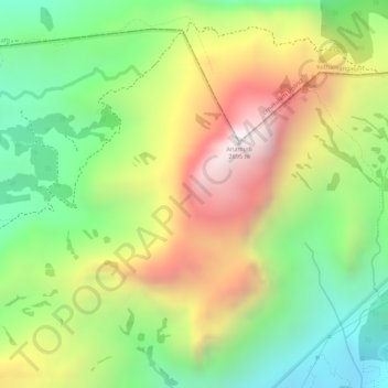
Nome: Mapa topográfico Western Ghats, altitude, relevo.
Altitude média: 2225 m
Altitude mínima: 1828 m
Altitude máxima: 2685 m
The range starts near south of the Tapti river and runs approximately 1,600 km (990 mi) through the states of Gujarat, Maharashtra, Karnataka, Goa, Kerala and Tamil Nadu ending at Marunthuvazh Malai near the southern tip of India. These hills cover 160,000 km2 (62,000 sq mi) and form the catchment area for complex riverine drainage systems that drain almost 40% of India. The Western Ghats block the southwest monsoon winds from reaching the Deccan Plateau. The average elevation is around 1,200 m (3,900 ft).
Outros mapas topográficos
Clique em um mapa para visualizar sua topografia, sua altitude e seu relevo.
Mattupetty
Mattupetty, Devikulam, Idukki District, Kerala, 685616, India
Altitude média: 1694 m
Pallivasal
India > Kerala > Devikulam > Pallivasal
Pallivasal, Devikulam, Idukki District, Kerala, India
Altitude média: 1304 m
Eravikulam National Park
India > Kerala > Devikulam > Lakkomukudi
Eravikulam National Park, Lakkomukudi, Devikulam, Idukki District, Kerala, India
Altitude média: 1701 m