
Mapa topográfico Yamuna River
Mapa interativo
Clique no mapa para exibir a altitude.
Yamuna River
The source of Yamuna lies in the Yamunotri Glacier at an elevation of 6,387 metres (20,955 ft), on the southwestern slopes of Banderpooch peaks, which lie in the Mussoorie range of the Lower Himalayas, north of Haridwar in Uttarkashi district, Uttarakhand. Yamunotri temple, a shrine dedicated to the goddess Yamuna, is one of the holiest shrines in Hinduism, and part of the Chota Char Dham Yatra circuit. Also standing close to the temple, on its 13-kilometre (8 mi) trek route that follows the right bank of the river, lies Markendeya Tirtha, where the sage Markandeya wrote the Markandeya Purana.
Sobre este mapa
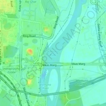
Nome: Mapa topográfico Yamuna River, altitude, relevo.
Local: Yamuna River, East Delhi, Delhi, India (28.62859 77.25325 28.63338 77.25951)
Altitude média: 206 m
Altitude mínima: 197 m
Altitude máxima: 229 m
Outros mapas topográficos
Clique em um mapa para visualizar sua topografia, sua altitude e seu relevo.
Delhi
India > Delhi > Kotwali Tehsil
The topography of the medieval fort Purana Qila on the banks of the river Yamuna matches the literary description of the citadel Indraprastha in the Sanskrit epic Mahabharata; however, excavations in the area have revealed no signs of an ancient built environment. From the early 13th century until the mid-19th…
Altitude média: 216 m
Bawana
India > Delhi > Narela Tehsil
Bawana has an average elevation of 213 metres (698 feet). It is surrounded by the villages of Nangal Thakran, Bajitpur, Daryapur, Majra Dabas, Pooth Khurd, Holabmi Khurd, Kheda Khurd, Holambi Kalan, Sultanpur Dabas and Ghogha. The area of the village under farming was 52000 bigha, but now most of this land has…
Altitude média: 219 m
Delhi
India > Delhi > Kotwali Tehsil
The topography of the medieval fort Purana Qila on the banks of the river Yamuna matches the literary description of the citadel Indraprastha in the Sanskrit epic Mahabharata; however, excavations in the area have revealed no signs of an ancient built environment. From the early 13th century until the mid-19th…
Altitude média: 216 m