
Mapa topográfico Padum
Mapa interativo
Clique no mapa para exibir a altitude.
Sobre este mapa
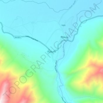
Nome: Mapa topográfico Padum, altitude, relevo.
Local: Padum, Zanskar, Kargil District, Ladakh, 194302, India (33.44914 76.85818 33.48914 76.89818)
Altitude média: 3632 m
Altitude mínima: 3507 m
Altitude máxima: 4198 m
Padum is at the centre of the tri armed Zanskar valley. It has an average elevation of 3,657 metres (11,998 feet). There are several villages to the north-east of Padum leading to Karsha monastery.