
Mapa topográfico Cauayan
Mapa interativo
Clique no mapa para exibir a altitude.
Sobre este mapa
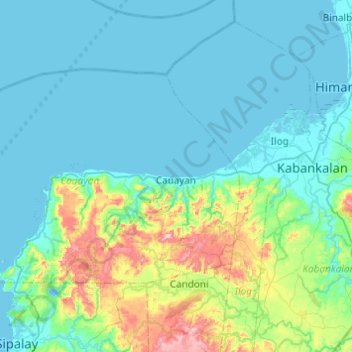
Nome: Mapa topográfico Cauayan, altitude, relevo.
Altitude média: 90 m
Altitude mínima: -2 m
Altitude máxima: 601 m
The municipality of Cauayan has a rugged topography. Mt. Malipantao, considered the highest peak in the province, separates the municipality from the town of Candoni and the city of Sipalay. Portion of the ranges are the remaining thick forest that needs protection where the watershed is located. The remaining portions of the municipality are slightly rolling to moderate large areas of flat lands center on the different barrios, which is much suited to agriculture.