
Mapa topográfico Fremont
Mapa interativo
Clique no mapa para exibir a altitude.
Sobre este mapa
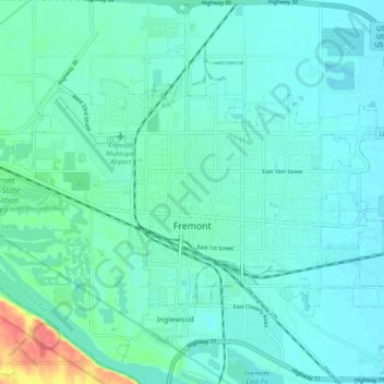
Nome: Mapa topográfico Fremont, altitude, relevo.
Local: Fremont, Dodge County, Nebraska, 68025, United States (41.41630 -96.54123 41.46409 -96.44426)
Altitude média: 365 m
Altitude mínima: 355 m
Altitude máxima: 414 m
According to the United States Census Bureau, the city has a total area of 8.85 square miles (22.92 km2), of which 8.80 square miles (22.79 km2) is land and 0.05 square miles (0.13 km2) is water. Fremont lies in the river plain between the Platte and Elkhorn rivers, at an elevation of approximately 366 meters (1,203 ft) above sea level.
Outros mapas topográficos
Clique em um mapa para visualizar sua topografia, sua altitude e seu relevo.
North Bend
United States > Nebraska > Dodge County
North Bend, Dodge County, Nebraska, United States
Altitude média: 388 m
Hooper
United States > Nebraska > Dodge County
Hooper, Dodge County, Nebraska, United States
Altitude média: 381 m
Winslow
United States > Nebraska > Dodge County
Winslow, Dodge County, Nebraska, 68072, United States
Altitude média: 374 m