
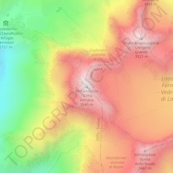
Mapa topográfico Vertainspitze - Cima Vertana
Mapa interativo
Clique no mapa para exibir a altitude.
Sobre este mapa
Nome: Mapa topográfico Vertainspitze - Cima Vertana, altitude, relevo.
Altitude média: 3055 m
Altitude mínima: 2454 m
Altitude máxima: 3527 m
Outros mapas topográficos
Clique em um mapa para visualizar sua topografia, sua altitude e seu relevo.
Untere Tartscher Alm
Italië > Trento-Zuid-Tirol > Stilfs - Stelvio > Untere Tartscher Alm
Untere Tartscher Alm, Stilfs - Stelvio, Vinschgau - Val Venosta, Bolzano - Bozen, Trento-Zuid-Tirol, Italië
Altitude média: 2128 m