
Mapa topográfico Clark Fork
Mapa interativo
Clique no mapa para exibir a altitude.
Sobre este mapa
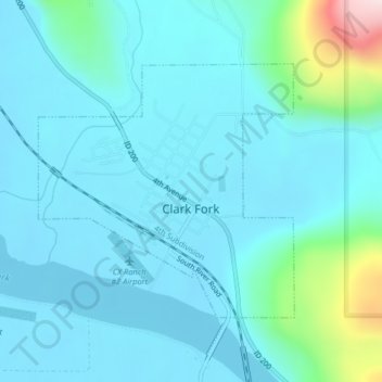
Nome: Mapa topográfico Clark Fork, altitude, relevo.
Local: Clark Fork, Bonner County, Idaho, United States (48.13748 -116.19191 48.15545 -116.16474)
Altitude média: 681 m
Altitude mínima: 625 m
Altitude máxima: 1040 m
Clark Fork is located at 48°8′50″N 116°10′42″W / 48.14722°N 116.17833°W / 48.14722; -116.17833 (48.147180, -116.178270), at an elevation of 2,090 feet (637 m) above sea level. The town is situated on the Clark Fork River, on the eastern shores of Lake Pend Oreille. in the northern panhandle of the state. According to the United States Census Bureau, the city has a total area of 0.92 square miles (2.38 km2), all of it land. The Lightning Creek passes just north and west of the town.
Outros mapas topográficos
Clique em um mapa para visualizar sua topografia, sua altitude e seu relevo.
Sandpoint
United States > Idaho > Bonner County
Sandpoint, Bonner County, Idaho, United States
Altitude média: 658 m
Hope
United States > Idaho > Bonner County
Hope, Bonner County, Idaho, United States
Altitude média: 763 m
Dover
United States > Idaho > Bonner County
Dover, Bonner County, Idaho, 83825, United States
Altitude média: 680 m
Priest Lake
United States > Idaho > Bonner County
Priest Lake, Bonner County, Idaho, United States
Altitude média: 1123 m
Sagle
United States > Idaho > Bonner County
Sagle, Bonner County, Idaho, 83860, United States
Altitude média: 692 m
Priest River
United States > Idaho > Bonner County
Priest River, Bonner County, Idaho, United States
Altitude média: 742 m
Pend Oreille River
United States > Idaho > Bonner County > Oldtown
Pend Oreille River, Oldtown, Bonner County, Idaho, 83822, United States
Altitude média: 657 m
Careywood
United States > Idaho > Bonner County
Careywood, Bonner County, Idaho, United States
Altitude média: 740 m
Ponderay
United States > Idaho > Bonner County
Ponderay, Bonner County, Idaho, 83852, United States
Altitude média: 652 m
Cedar Creek
United States > Idaho > Bonner County
Cedar Creek, Bonner County, Idaho, United States
Altitude média: 748 m
Kootenai
United States > Idaho > Bonner County
Kootenai, Bonner County, Idaho, 83840, United States
Altitude média: 641 m
Sandpoint
United States > Idaho > Bonner County > Sandpoint
Sandpoint, Bonner County, Idaho, 83852, United States
Altitude média: 687 m
Blanchard
United States > Idaho > Bonner County
Blanchard, Bonner County, Idaho, 83804, United States
Altitude média: 718 m