
Mapa topográfico Bhubaneshwar
Mapa interativo
Clique no mapa para exibir a altitude.
Sobre este mapa
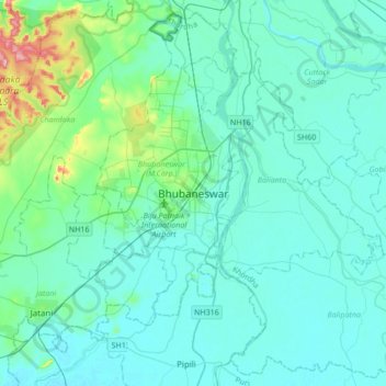
Nome: Mapa topográfico Bhubaneshwar, altitude, relevo.
Altitude média: 30 m
Altitude mínima: 6 m
Altitude máxima: 199 m
Bhubaneswar is in Khordha district of Odisha. It is in the eastern coastal plains, along the axis of the Eastern Ghats mountains. The city has an average altitude of 45 m (148 ft) above sea level. It lies southwest of the Mahanadi River that forms the northern boundary of Bhubaneswar metropolitan area, within its delta.
Outros mapas topográficos
Clique em um mapa para visualizar sua topografia, sua altitude e seu relevo.
Bhubaneswar Municipal Corporation
India > Odisha > Bhubaneswar (M.Corp.) > Bhubaneswar Municipal Corporation
Bhubaneswar Municipal Corporation, Bhubaneswar (M.Corp.), Khordha, Odisha, India
Altitude média: 37 m