
Mapa topográfico Glashütten
Mapa interativo
Clique no mapa para exibir a altitude.
Sobre este mapa
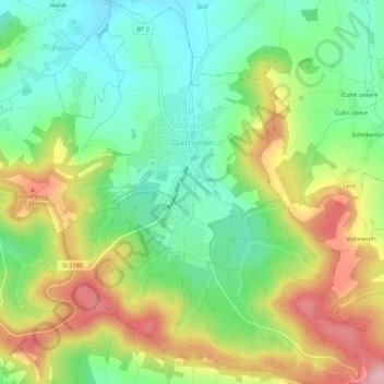
Nome: Mapa topográfico Glashütten, altitude, relevo.
Altitude média: 468 m
Altitude mínima: 399 m
Altitude máxima: 569 m
Die Einöden Höhe und Poppenwiese sind mittlerweile in dem Gemeindeteil Glashütten aufgegangen.
Outros mapas topográficos
Clique em um mapa para visualizar sua topografia, sua altitude e seu relevo.
Warmensteinach
Deutschland > Bayern > Landkreis Bayreuth
Warmensteinach, Landkreis Bayreuth, Bayern, 95485, Deutschland
Altitude média: 738 m
Speichersdorf
Deutschland > Bayern > Landkreis Bayreuth
Speichersdorf, Landkreis Bayreuth, Bayern, 95469, Deutschland
Altitude média: 482 m
Mehlmeisel
Deutschland > Bayern > Landkreis Bayreuth
Mehlmeisel, Landkreis Bayreuth, Bayern, 95694, Deutschland
Altitude média: 670 m
Veldensteiner Forst
Deutschland > Bayern > Landkreis Bayreuth
Veldensteiner Forst, Landkreis Bayreuth, Bayern, Deutschland
Altitude média: 450 m
Pottenstein
Deutschland > Bayern > Landkreis Bayreuth
Pottenstein, Landkreis Bayreuth, Bayern, 91278, Deutschland
Altitude média: 471 m
Bad Berneck im Fichtelgebirge
Deutschland > Bayern > Landkreis Bayreuth
Bad Berneck im Fichtelgebirge, Landkreis Bayreuth, Bayern, 95460, Deutschland
Altitude média: 521 m
Goldkronach
Deutschland > Bayern > Landkreis Bayreuth
Goldkronach, Landkreis Bayreuth, Bayern, 95497, Deutschland
Altitude média: 527 m
Aufseß
Deutschland > Bayern > Landkreis Bayreuth > Aufseß
Aufseß, Hollfeld (VGem), Landkreis Bayreuth, Bayern, 91347, Deutschland
Altitude média: 445 m