
Mapa topográfico Cebu
Mapa interativo
Clique no mapa para exibir a altitude.
Sobre este mapa
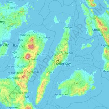
Nome: Mapa topográfico Cebu, altitude, relevo.
Local: Cebu, Central Visayas, Philippines (9.32785 123.23527 11.62616 124.66718)
Altitude média: 91 m
Altitude mínima: -2 m
Altitude máxima: 2362 m
Coal was first discovered in Cebu about 1837. There were 15 localities over the whole island, on both coast; some desultory mining had been carried out Naga near Mount Uling, but most serious operations were at Licos and Camansi west of Compostela and Danao. Active work ceased about 1895 with insurrections, and no production worked for more than ten years. A topographic and geologic survey of Compostela, Danao and Carmen took place in 1906. The Compostela-Danao coalfield contained about six million workable tons. The tramroads, one from Danao to Camansi, one from Compostela to Mount Licos, were undertaken in 1895, together with a wagon road built in 1877, from Cotcot to Dapdap.
Outros mapas topográficos
Clique em um mapa para visualizar sua topografia, sua altitude e seu relevo.
Cebu City
Philippines > Cebu > Cebu City
Cebu City, Cebu, Central Visayas, 6000, Philippines
Altitude média: 140 m
Pinamungajan
Pinamungajan, Cebu, Central Visayas, 6039, Philippines
Altitude média: 35 m
Damolog
Philippines > Cebu > Sogod
Damolog, Sogod, Cebu, Central Visayas, 6007, Philippines
Altitude média: 70 m
Basak
Philippines > Cebu > Badian
Basak, Badian, Cebu, Central Visayas, 6031, Philippines
Altitude média: 305 m
Yati
Philippines > Cebu > Liloan
Yati, Liloan, Cebu, Central Visayas, 6002, Philippines
Altitude média: 14 m
Bantayan Island
Philippines > Cebu > Sungko
Bantayan Island, Sungko, Cebu, Central Visayas, Philippines
Altitude média: 5 m
Caurasan
Philippines > Cebu > Carmen
Caurasan, Carmen, Cebu, Central Visayas, Philippines
Altitude média: 531 m
Cogon
Philippines > Cebu > Cordova
Cogon, Cordova, Cebu, Central Visayas, 6017, Philippines
Altitude média: 2 m
Maghaway
Philippines > Cebu > Talisay
Maghaway, Talisay, Cebu, Central Visayas, 6045, Philippines
Altitude média: 122 m
Basdiot
Philippines > Cebu > Moalboal
Basdiot, Moalboal, Cebu, Central Visayas, 6032, Philippines
Altitude média: 5 m
Tubod-Bitoon
Philippines > Cebu > Dumanjug
Tubod-Bitoon, Dumanjug, Cebu, Central Visayas, 6035, Philippines
Altitude média: 82 m
Cadulawan
Philippines > Cebu > Minglanilla
Cadulawan, Minglanilla, Cebu, Central Visayas, 6046, Philippines
Altitude média: 98 m
Lanipga
Philippines > Cebu > Consolacion
Lanipga, Consolacion, Cebu, Central Visayas, Philippines
Altitude média: 216 m
Maravilla Public Beach
Philippines > Cebu > Maravilla
Maravilla Public Beach, Maravilla, Cebu, Central Visayas, Philippines
Altitude média: 24 m
Badian Island
Philippines > Cebu > Zaragosa
Badian Island, Zaragosa, Cebu, Central Visayas, Philippines
Altitude média: 7 m
Jumangpas
Philippines > Cebu > Samboan
Jumangpas, Samboan, Cebu, Central Visayas, 6027, Philippines
Altitude média: 423 m
Bagalnga
Philippines > Cebu > Compostela
Bagalnga, Compostela, Cebu, Central Visayas, 6003, Philippines
Altitude média: 90 m
Nalusuan Island
Philippines > Cebu > Cordova > Gilutongan
Nalusuan Island, Gilutongan, Cordova, Cebu, Central Visayas, Philippines
Altitude média: 0 m
Tinabyonan
Tinabyonan, Cebu, Central Visayas, 6006, Philippines
Altitude média: 304 m
Mananga River
Philippines > Cebu > Talisay
Mananga River, Talisay, Cebu, Central Visayas, Philippines
Altitude média: 17 m
Cebu
Philippines > Cebu > Cebu City
Cebu, Cebu City, Cebu, Central Visayas, Philippines
Altitude média: 103 m
Olango Island
Philippines > Cebu > Lapu-Lapu
Olango Island, Lapu-Lapu, Cebu, Central Visayas, Philippines
Altitude média: 2 m
Consolacion
Consolacion, Cebu, Central Visayas, 6001, Philippines
Altitude média: 31 m