
Mapa topográfico Savannah
Mapa interativo
Clique no mapa para exibir a altitude.
Sobre este mapa
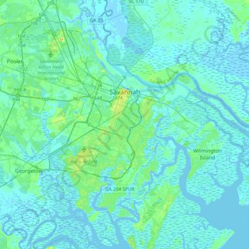
Nome: Mapa topográfico Savannah, altitude, relevo.
Local: Savannah, Chatham County, Georgia, United States of America (31.88785 -81.37143 32.18966 -81.02952)
Altitude média: 4 m
Altitude mínima: -5 m
Altitude máxima: 33 m
Savannah is prone to flooding, due to abundant rainfall, an elevation at just above sea level, and the shape of the coastline, which poses a greater surge risk during hurricanes. The city currently uses five canals. In addition, several pumping stations have been built to help reduce the effects of flash flooding.