
Mapa topográfico Garlipp
Mapa interativo
Clique no mapa para exibir a altitude.
Sobre este mapa
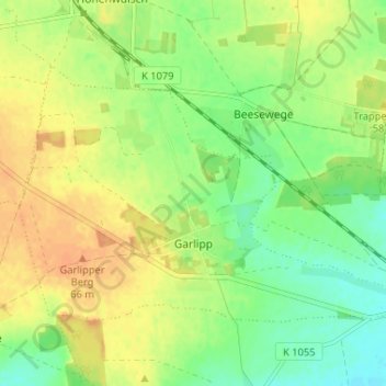
Nome: Mapa topográfico Garlipp, altitude, relevo.
Altitude média: 53 m
Altitude mínima: 36 m
Altitude máxima: 69 m
Outros mapas topográficos
Clique em um mapa para visualizar sua topografia, sua altitude e seu relevo.
Gutshaus Hohenwulsch
Deutschland > Sachsen-Anhalt > Stendal > Bismark (Altmark) > Hohenwulsch
Gutshaus Hohenwulsch, 1, Am Schloß, Hohenwulsch, Bismark (Altmark), Stendal, Sachsen-Anhalt, 39629, Deutschland
Altitude média: 55 m
Hohenwulsch
Deutschland > Sachsen-Anhalt > Stendal > Bismark (Altmark)
Hohenwulsch, Bismark (Altmark), Stendal, Sachsen-Anhalt, Deutschland
Altitude média: 50 m
Klinke
Deutschland > Sachsen-Anhalt > Stendal > Bismark (Altmark) > Klinke
Klinke, Badingen, Bismark (Altmark), Stendal, Sachsen-Anhalt, 39599, Deutschland
Altitude média: 50 m
Trappenberg
Deutschland > Sachsen-Anhalt > Stendal > Bismark (Altmark)
Trappenberg, Bismark (Altmark), Stendal, Sachsen-Anhalt, 39628, Deutschland
Altitude média: 50 m