
Mapa topográfico Turpan
Mapa interativo
Clique no mapa para exibir a altitude.
Sobre este mapa
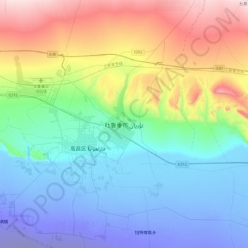
Nome: Mapa topográfico Turpan, altitude, relevo.
Local: Turpan, Gaochang District, Turpan, Xinjiang, 838000, China (42.78003 89.02405 43.10003 89.34405)
Altitude média: 104 m
Altitude mínima: -141 m
Altitude máxima: 626 m
Turpan is located about 150 km (93 mi) southeast of Ürümqi, Xinjiang's capital, in a mountain basin, on the northern side of the Turpan Depression, at an elevation of 30 m (98 ft) above sea level. Outside of Turpan is a small volcanic cone, the Turfan volcano, that is said to have erupted in 1120 as described in the Song Dynasty. In June 1995, a book of standard names for local geography was published.