
Mapa topográfico Xhierfomont
Mapa interativo
Clique no mapa para exibir a altitude.
Sobre este mapa
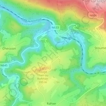
Nome: Mapa topográfico Xhierfomont, altitude, relevo.
Local: Xhierfomont, Stoumont, Verviers, Liège, Wallonie, 4987, Belgique (50.38493 5.75930 50.42493 5.79930)
Altitude média: 295 m
Altitude mínima: 178 m
Altitude máxima: 538 m
Outros mapas topográficos
Clique em um mapa para visualizar sua topografia, sua altitude e seu relevo.
Borgoumont
Belgique > Liège > Verviers > Stoumont
Borgoumont, Stoumont, Verviers, Liège, Wallonie, 4987, Belgique
Altitude média: 398 m
Château de Froidcourt
Belgique > Liège > Verviers > Stoumont
Château de Froidcourt, 8, Froidcour, Stoumont, Verviers, Liège, Wallonie, 4987, Belgique
Altitude média: 317 m
Grimbiémont
Belgique > Liège > Verviers > Stoumont
Grimbiémont, Stoumont, Verviers, Liège, Wallonie, 4987, Belgique
Altitude média: 345 m