
Mapa topográfico Dornum
Mapa interativo
Clique no mapa para exibir a altitude.
Sobre este mapa
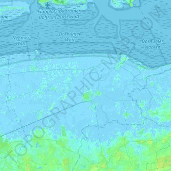
Nome: Mapa topográfico Dornum, altitude, relevo.
Local: Dornum, Landkreis Aurich, Lower Saxony, 26553, Germany (53.61923 7.31399 53.69312 7.55813)
Altitude média: 1 m
Altitude mínima: -4 m
Altitude máxima: 9 m
Outros mapas topográficos
Clique em um mapa para visualizar sua topografia, sua altitude e seu relevo.
Wiegboldsbur
Germany > Lower Saxony > Landkreis Aurich > Wiegboldsbur
Wiegboldsbur, Südbrookmerland, Landkreis Aurich, Lower Saxony, Germany
Altitude média: 0 m
Wiesmoor
Germany > Lower Saxony > Landkreis Aurich
Wiesmoor, Landkreis Aurich, Lower Saxony, 26639, Germany
Altitude média: 9 m
Greetsiel
Germany > Lower Saxony > Landkreis Aurich
Greetsiel, Krummhörn, Landkreis Aurich, Lower Saxony, 26736, Germany
Altitude média: -1 m
Brockzetel
Germany > Lower Saxony > Landkreis Aurich > Aurich
Brockzetel, Brockzetel und Wiesens, Aurich, Landkreis Aurich, Lower Saxony, Germany
Altitude média: 10 m
Norderney
Germany > Lower Saxony > Landkreis Aurich > Norderney
Norderney, Landkreis Aurich, Lower Saxony, 26548, Germany
Altitude média: 0 m
Norden
Germany > Lower Saxony > Landkreis Aurich
Norden, Landkreis Aurich, Lower Saxony, 26506, Germany
Altitude média: 1 m