
Faça uma doação
Prepare-se para a sua próxima aventura:
Como Associado da Amazon, este site recebe uma comissão sobre compras elegíveis sem custo adicional para si.
Mapa topográfico Nevado de Toluca
Clique no mapa para exibir a altitude.
Faça uma doação
Prepare-se para a sua próxima aventura:
Como Associado da Amazon, este site recebe uma comissão sobre compras elegíveis sem custo adicional para si.
Nevado de Toluca
Most of the other sites are found on the crater's walls and peaks. One of the sites is called Xicotepec which is at the top of a rocky dome known as the Cerro de Ombligo (Spanish for "the navel"). Principally green obsidian blades and multicolored ceramic has been found here. On the north side of the crater is Pico Sahagun, with ceramic pieces, Picos Heilprin North and South in which various types of objects have been found, and El Mirador, which is thought to be related the marking of the zenith of the sun. A stele found here seems to indicate this. The site at the highest altitude is Pico Noreste at 4,130 meters above sea level. It is a small platform with drainage on which has been found highly deteriorated ceramic pieces. On the west side is the Cerro Prieto Cave, which is really a rock shelter which is more than 60 meters high. Not only does it contain evidence of pre-Hispanic visits but also has been a shrine to the Archangel Michael since the colonial period.
Faça uma doação
Prepare-se para a sua próxima aventura:
Como Associado da Amazon, este site recebe uma comissão sobre compras elegíveis sem custo adicional para si.
Sobre este mapa
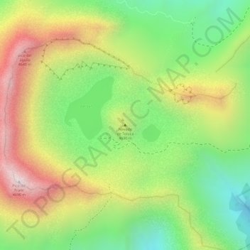
Nome: Mapa topográfico Nevado de Toluca, altitude, relevo.
Local: Nevado de Toluca, Toluca, State of Mexico, Mexico (19.10790 -99.75554 19.10800 -99.75544)
Altitude média: 4280 m
Altitude mínima: 3935 m
Altitude máxima: 4659 m
Faça uma doação
Prepare-se para a sua próxima aventura:
Como Associado da Amazon, este site recebe uma comissão sobre compras elegíveis sem custo adicional para si.