
Mapa topográfico Mettmenstetten
Mapa interativo
Clique no mapa para exibir a altitude.
Sobre este mapa
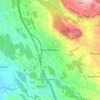
Nome: Mapa topográfico Mettmenstetten, altitude, relevo.
Local: Mettmenstetten, Bezirk Affoltern, Zurich, 8932, Switzerland (47.21838 8.43208 47.26832 8.50067)
Altitude média: 506 m
Altitude mínima: 389 m
Altitude máxima: 727 m
The municipality includes the village of Mettmenstetten, with the two core sections of Ober- and Untermettmenstetten as well as the other sections; Dachlissen, Eigi, Grossholz, Herferswil, Hübscheren, Rossau and Wissenbach. It is located an elevation of 460 m (1,510 ft).
Outros mapas topográficos
Clique em um mapa para visualizar sua topografia, sua altitude e seu relevo.
Aeugst am Albis
Switzerland > Zurich > Bezirk Affoltern
Aeugst am Albis, Bezirk Affoltern, Zurich, Switzerland
Altitude média: 668 m
Wängibad
Switzerland > Zurich > Bezirk Affoltern > Aeugst am Albis
Wängibad, Aeugst am Albis, Bezirk Affoltern, Zurich, 8914, Switzerland
Altitude média: 595 m