
Mapa topográfico Gannan
Mapa interativo
Clique no mapa para exibir a altitude.
Sobre este mapa
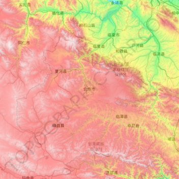
Nome: Mapa topográfico Gannan, altitude, relevo.
Altitude média: 3075 m
Altitude mínima: 1621 m
Altitude máxima: 4740 m
Gannan, as illustrated by this chart for Xiahe, has an alpine subarctic climate (Köppen Dwc) that grades into an alpine climate (ETH) at the highest elevations. The climate is characterised by mild, rainy summers and frigid, but dry and sunny, winters.