
Mapa topográfico San Rafel Swell overlook
Mapa interativo
Clique no mapa para exibir a altitude.
Sobre este mapa
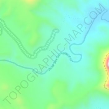
Nome: Mapa topográfico San Rafel Swell overlook, altitude, relevo.
Altitude média: 1491 m
Altitude mínima: 1370 m
Altitude máxima: 1885 m
Outros mapas topográficos
Clique em um mapa para visualizar sua topografia, sua altitude e seu relevo.
Orangeville
United States > Utah > Emery County
Orangeville, Emery County, Utah, 84537, United States
Altitude média: 1776 m
Castle Dale
United States > Utah > Emery County
Castle Dale, Emery County, Utah, 84513, United States
Altitude média: 1758 m
Huntington
United States > Utah > Emery County > Huntington
Huntington, Emery County, Utah, 84528, United States
Altitude média: 1767 m
Castle Dale
United States > Utah > Emery County > Castle Dale > Castle Dale
Castle Dale, Emery County, Utah, 84513, United States
Altitude média: 1745 m
The Wickiup
United States > Utah > Emery County
The Wickiup, Emery County, Utah, United States
Altitude média: 1979 m
Joes Valley Reservoir
United States > Utah > Emery County
Joes Valley Reservoir, Emery County, Utah, United States
Altitude média: 2282 m
Green River
United States > Utah > Emery County
Green River, Emery County, Utah, 84525, United States
Altitude média: 1349 m