
Mapa topográfico Upper Saucon
Mapa interativo
Clique no mapa para exibir a altitude.
Sobre este mapa
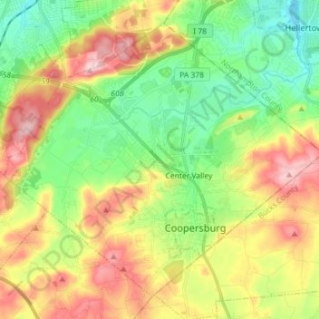
Nome: Mapa topográfico Upper Saucon, altitude, relevo.
Local: Upper Saucon, Lehigh County, Pennsylvania, United States (40.48798 -75.47584 40.58115 -75.33305)
Altitude média: 175 m
Altitude mínima: 77 m
Altitude máxima: 316 m
According to the United States Census Bureau, the township has a total area of 24.6 square miles (63.7 km2), of which 24.5 square miles (63.4 km2) are land and 0.2 square miles (0.4 km2), or 0.59%, are water. Its boundary with Salisbury Township is located on South Mountain. Elevations range from 340 feet (100 m) in Spring Valley to 1,042 feet (318 m) at Bauer Rock atop South Mountain in Big Rock County Park. Upper Saucon is in the Delaware River watershed and is drained by Saucon Creek into the Lehigh River, except for a very small area in the extreme south just southwest of Locust Valley, which is drained by Unami Creek into Perkiomen Creek and the Schuylkill River.
Outros mapas topográficos
Clique em um mapa para visualizar sua topografia, sua altitude e seu relevo.
Center Valley
United States > Pennsylvania > Lehigh County > Upper Saucon
Center Valley, Upper Saucon, Lehigh County, Pennsylvania, 18034, United States
Altitude média: 152 m