
Mapa topográfico Woodburn
Mapa interativo
Clique no mapa para exibir a altitude.
Sobre este mapa
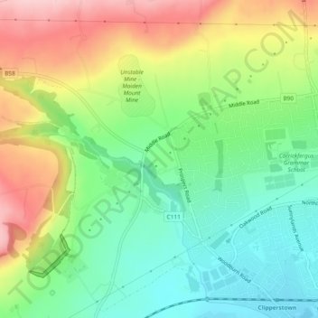
Nome: Mapa topográfico Woodburn, altitude, relevo.
Altitude média: 87 m
Altitude mínima: 10 m
Altitude máxima: 199 m
Outros mapas topográficos
Clique em um mapa para visualizar sua topografia, sua altitude e seu relevo.
Carrickfergus Castle
United Kingdom > Northern Ireland > Carrickfergus
Carrickfergus Castle, Marine Highway, Carrickfergus, County Antrim, Northern Ireland, BT38 7DF, United Kingdom
Altitude média: 8 m