
Mapa topográfico Blenheim
Mapa interativo
Clique no mapa para exibir a altitude.
Sobre este mapa
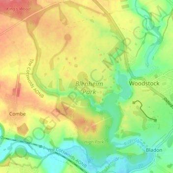
Nome: Mapa topográfico Blenheim, altitude, relevo.
Altitude média: 99 m
Altitude mínima: 67 m
Altitude máxima: 134 m
Outros mapas topográficos
Clique em um mapa para visualizar sua topografia, sua altitude e seu relevo.
Witney
United Kingdom > England > West Oxfordshire > Witney
Witney, West Oxfordshire, Oxfordshire, South East, England, OX28 6BJ, United Kingdom
Altitude média: 95 m
Carterton
United Kingdom > England > West Oxfordshire > Carterton
Carterton, West Oxfordshire, Oxfordshire, South East, England, OX18 3XX, United Kingdom
Altitude média: 95 m
Burford
United Kingdom > England > West Oxfordshire > Burford
Burford, Oxfordshire, South East, England, OX18, United Kingdom
Altitude média: 140 m
River Windrush
United Kingdom > England > West Oxfordshire
River Windrush, West Oxfordshire, Oxfordshire, South East, England, OX29 9SX, United Kingdom
Altitude média: 101 m
Tackley
United Kingdom > England > West Oxfordshire > Tackley
Tackley, West Oxfordshire, Oxfordshire, South East, England, OX5 3FR, United Kingdom
Altitude média: 94 m
River Evenlode
United Kingdom > England > West Oxfordshire
River Evenlode, West Oxfordshire, Oxfordshire, South East, England, OX29 8DW, United Kingdom
Altitude média: 106 m
Soho Farmhouse
United Kingdom > England > West Oxfordshire > Little Tew
Soho Farmhouse, Great Tew, Little Tew, West Oxfordshire, Oxfordshire, South East England, England, OX7 4JS, United Kingdom
Altitude média: 163 m
Asthall
United Kingdom > England > West Oxfordshire > Asthall
Asthall, West Oxfordshire, Oxfordshire, South East England, England, United Kingdom
Altitude média: 129 m
Upper Milton
United Kingdom > England > West Oxfordshire > Milton-under-Wychwood > Upper Milton
Upper Milton, Milton-under-Wychwood, West Oxfordshire, Oxfordshire, South East England, England, OX7 6EY, United Kingdom
Altitude média: 153 m
Mount Skippett
United Kingdom > England > West Oxfordshire > Ramsden > Mount Skippett
Mount Skippett, Ramsden, West Oxfordshire, Oxfordshire, South East England, England, OX7 3AP, United Kingdom
Altitude média: 135 m
Radford
United Kingdom > England > West Oxfordshire > Kiddington > Radford
Radford, Enstone, Kiddington, West Oxfordshire, Oxfordshire, South East England, England, OX7 4EB, United Kingdom
Altitude média: 141 m
Woodstock
United Kingdom > England > West Oxfordshire > Woodstock
Woodstock, West Oxfordshire, Oxfordshire, South East England, England, OX20 1TH, United Kingdom
Altitude média: 93 m
Nether Worton
United Kingdom > England > West Oxfordshire > Nether Worton
Nether Worton, Worton, West Oxfordshire, Oxfordshire, South East England, England, OX7 7AT, United Kingdom
Altitude média: 131 m
Bladon
United Kingdom > England > West Oxfordshire > Bladon
Bladon, West Oxfordshire, Oxfordshire, South East, England, OX20 1RQ, United Kingdom
Altitude média: 86 m
River Glyme
United Kingdom > England > West Oxfordshire
River Glyme, West Oxfordshire, Oxfordshire, South East, England, OX7 4EB, United Kingdom
Altitude média: 133 m
Kingham
United Kingdom > England > West Oxfordshire > Kingham
Kingham, West Oxfordshire, Oxfordshire, South East, England, OX7 6YE, United Kingdom
Altitude média: 125 m
Widford
United Kingdom > England > West Oxfordshire > Widford
Widford, West Oxfordshire, Oxfordshire, South East, England, OX18 4DU, United Kingdom
Altitude média: 127 m
Foscot
United Kingdom > England > West Oxfordshire > Foscot
Foscot, West Oxfordshire, Oxfordshire, South East, England, OX7 6RJ, United Kingdom
Altitude média: 121 m
Worton
United Kingdom > England > West Oxfordshire
Worton, West Oxfordshire, Oxfordshire, South East, England, United Kingdom
Altitude média: 128 m
Cornbury and Wychwood
United Kingdom > England > West Oxfordshire
Cornbury and Wychwood, West Oxfordshire, Oxfordshire, South East, England, United Kingdom
Altitude média: 146 m