
Mapa topográfico Ardèche
Mapa interativo
Clique no mapa para exibir a altitude.
Sobre este mapa
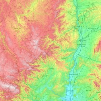
Nome: Mapa topográfico Ardèche, altitude, relevo.
Local: Ardèche, Auvergne-Rhône-Alpes, Metropolitan France, France (44.26434 3.86110 45.36622 4.88624)
Altitude média: 639 m
Altitude mínima: 40 m
Altitude máxima: 1702 m
The department, corresponding to the ancient province of Vivarais, is part of the current region of Auvergne-Rhône-Alpes and is surrounded by the French departments of Drôme, Vaucluse, Gard, Lozère, Haute-Loire, Loire and Isère. It is a land of great contrasts: at the lowest it is at a mere 40 metres of elevation above sea level at the point at which the Ardèche river flows into the Rhône (in the southeast of the department) up to 1,754 metres at Mont Mézenc (centre-west), it is bordered to the east by the length of the Rhône valley for 140 km and to the west by the high plateaus of the Massif Central.
Outros mapas topográficos
Clique em um mapa para visualizar sua topografia, sua altitude e seu relevo.
Saint-Julien-Labrousse
France > Auvergne-Rhône-Alpes > Ardèche > Belsentes
Saint-Julien-Labrousse, Belsentes, Tournon-sur-Rhône, Ardèche, Auvergne-Rhône-Alpes, Metropolitan France, 07160, France
Altitude média: 625 m
Ruisseau de l'Escourt
France > Auvergne-Rhône-Alpes > Ardèche > Malarce-sur-la-Thines > Fontoux
Ruisseau de l'Escourt, Fontoux, Malarce-sur-la-Thines, Largentière, Ardèche, Auvergne-Rhône-Alpes, Metropolitan France, 07140, France
Altitude média: 313 m