
Mapa topográfico Somerset
Mapa interativo
Clique no mapa para exibir a altitude.
Sobre este mapa
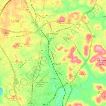
Nome: Mapa topográfico Somerset, altitude, relevo.
Local: Somerset, Pulaski County, Kentucky, 42503, United States (37.03135 -84.64756 37.12006 -84.56484)
Altitude média: 295 m
Altitude mínima: 202 m
Altitude máxima: 398 m
Somerset is located at 37°4′59″N 84°36′34″W / 37.08306°N 84.60944°W / 37.08306; -84.60944 (37.082966, −84.609387), and the downtown (central) part of the city is at an elevation of 974 feet above sea level. The city is located at the eastern end of Kentucky's Mississippian Plateau (or Pennyroyal Plateau); however, the micropolitan area extends eastward into the Appalachian Plateau (or Eastern Kentucky Coalfield), and northward to Kentucky's Outer Bluegrass region. Thus, the area shows variations in landforms and scenery.
Outros mapas topográficos
Clique em um mapa para visualizar sua topografia, sua altitude e seu relevo.
Sinking Valley
United States > Kentucky > Pulaski County
Sinking Valley, Pulaski County, Kentucky, United States
Altitude média: 309 m
Eubank
United States > Kentucky > Pulaski County
Eubank, Pulaski County, Kentucky, United States
Altitude média: 354 m
Oil Center
United States > Kentucky > Pulaski County
Oil Center, Pulaski County, Kentucky, United States
Altitude média: 268 m
Burnside
United States > Kentucky > Pulaski County
Burnside, Pulaski County, Kentucky, United States
Altitude média: 251 m
Science Hill
United States > Kentucky > Pulaski County
Science Hill, Pulaski County, Kentucky, United States
Altitude média: 327 m
Elrod
United States > Kentucky > Pulaski County > Elrod
Elrod, Pulaski County, Kentucky, United States
Altitude média: 298 m
Keno
United States > Kentucky > Pulaski County
Keno, Pulaski County, Kentucky, United States
Altitude média: 308 m