

Mapa topográfico Cache County
Clique no mapa para exibir a altitude.
Cache County
Cache County lies on the north edge of Utah. Its north border abuts the south border of the state of Idaho. On the western edge of the county are the Wellsville Mountains and on the eastern edge are the Bear River Mountains, both northern branches of the Wasatch Range. The Cache Valley reaches north to the state border. The Bear River Mountains, the northernmost extension of the Wasatch Range, cover the eastern half of the county. The county's highest elevation is Naomi Peak in the northeast part of the county, at 9,979 feet (3,042 m) above sea level. The Bear River flows through Cache Valley. The county has a total area of 1,173 square miles (3,040 km2), of which 1,165 square miles (3,020 km2) is land and 8.2 square miles (21 km2) (0.7%) is water.
Sobre este mapa
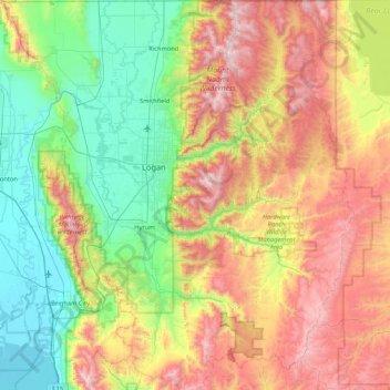
Nome: Mapa topográfico Cache County, altitude, relevo.
Local: Cache County, Utah, United States (41.36882 -112.16611 41.99955 -111.40158)
Altitude média: 1906 m
Altitude mínima: 1279 m
Altitude máxima: 3003 m
Outros mapas topográficos
Clique em um mapa para visualizar sua topografia, sua altitude e seu relevo.
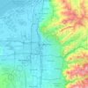
Salt Lake City
United States > Utah > Salt Lake County > Salt Lake City
Salt Lake City has an area of 110.4 square miles (286 km2) and an average elevation of 4,327 feet (1,319 m) above sea level. The lowest point within the boundaries of the city is 4,210 feet (1,280 m) near the Jordan River and the Great Salt Lake, and the highest is Grandview Peak, at 9,410 feet (2,868 m).
Altitude média: 1625 m





Panguitch Lake Resort
United States > Utah > Garfield County > Panguitch Lake Resort
Altitude média: 2549 m