
Faça uma doação
Prepare-se para a sua próxima aventura:
Como Associado da Amazon, este site recebe uma comissão sobre compras elegíveis sem custo adicional para si.
Mapa topográfico West Palm Beach
Clique no mapa para exibir a altitude.
Faça uma doação
Prepare-se para a sua próxima aventura:
Como Associado da Amazon, este site recebe uma comissão sobre compras elegíveis sem custo adicional para si.
West Palm Beach
Northwood Hills Historic District: On August 4, 2003, the City Commission designated the Northwood Hills neighborhood as the 13th Historic District in the City of West Palm Beach. Northwood Hills comprises the area from 29th Street on the South to 39th Court on the North. The east side of Windsor is the Western boundary, and Greenwood Avenue is the Eastern boundary. The Neighborhood Association has worked several years to achieve the distinction of historic designation. This is the first district to be designated since 1996. Northwood Hills has a number of Mission Revival houses, a significant collection of Post-World War II architecture, a unique street layout, and one of the highest elevations in the city. The Northwood Hills neighborhood has also elected to allow the establishment of Bed and Breakfast establishments within the neighborhood.
Faça uma doação
Prepare-se para a sua próxima aventura:
Como Associado da Amazon, este site recebe uma comissão sobre compras elegíveis sem custo adicional para si.
Sobre este mapa
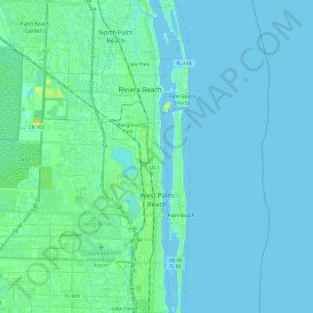
Nome: Mapa topográfico West Palm Beach, altitude, relevo.
Local: West Palm Beach, Palm Beach County, Florida, United States (26.64442 -80.21463 26.84017 -80.04348)
Altitude média: 4 m
Altitude mínima: -2 m
Altitude máxima: 31 m
Faça uma doação
Prepare-se para a sua próxima aventura:
Como Associado da Amazon, este site recebe uma comissão sobre compras elegíveis sem custo adicional para si.
Outros mapas topográficos
Clique em um mapa para visualizar sua topografia, sua altitude e seu relevo.