
Mapa topográfico Guelph
Mapa interativo
Clique no mapa para exibir a altitude.
Sobre este mapa
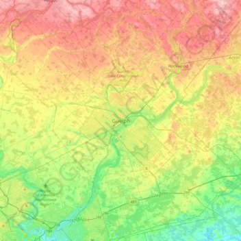
Nome: Mapa topográfico Guelph, altitude, relevo.
Local: Guelph, Southwestern Ontario, Ontario, N1H 4E7, Canada (43.38605 -80.40933 43.70605 -80.08933)
Altitude média: 344 m
Altitude mínima: 267 m
Altitude máxima: 440 m
This region of Ontario has cold winters and warm, humid summers, falling into the Köppen climate classification Dfb zone, with moderately high rainfall and snowfall. It is generally a couple of degrees cooler than lower elevation regions on the Great Lakes shorelines, especially so in winter, the exception being on some spring afternoons when the lack of an onshore breeze boosts temperatures well above those found lakeside.
Outros mapas topográficos
Clique em um mapa para visualizar sua topografia, sua altitude e seu relevo.
John Gamble Park
John Gamble Park, Hanlon Creek, Guelph, Ontario, Canada
Altitude média: 327 m
The Arboretum
The Arboretum, Guelph, Southwestern Ontario, Ontario, Canada
Altitude média: 332 m
Silver Creek Conservation Area
Silver Creek Conservation Area, The Ward, Guelph, Southwestern Ontario, Ontario, N1E 3E9, Canada
Altitude média: 326 m