
Mapa topográfico Romford
Mapa interativo
Clique no mapa para exibir a altitude.
Sobre este mapa
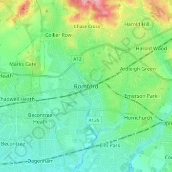
Nome: Mapa topográfico Romford, altitude, relevo.
Local: Romford, Greater London, England, RM1 1RX, United Kingdom (51.53605 0.14226 51.61605 0.22226)
Altitude média: 29 m
Altitude mínima: 1 m
Altitude máxima: 109 m
The town centre is about 50 feet (15 m) above sea level on a gravel terrace rising from the River Thames. The north of the town has developed on London Clay and is situated as much as 150 ft (46 m) above sea level. A continuous gentle rise in the eastern suburbs towards Gidea Park and Harold Wood peaks around 177 feet (54 m) around the Harold Court. On the northern side, Harold Hill peaks at 75 m (246 ft). The semi-rural area north of Collier Row and Harold Hill consists of many rolls of hills, with elevation peaking at the village of Havering-atte-Bower, 344 feet (105 m). The town centre is for the most part contained within a ring road formed of St Edwards Way, Mercury Gardens, Thurloe Gardens, Oldchurch Road and Waterloo Road. The market place and much of South Street and the High Street are pedestrianised. The railway cuts through the town from east to west on a viaduct, with the bulk of the central Romford area to its north. The River Rom flows through the town in underground channels and joins the Thames after flowing through Hornchurch; elsewhere along its course it is known as the River Beam and forms part of the strategic waterways Blue Ribbon Network. Romford has formed part of the continuously built-up area of London since the 1930s and is contiguous with Rush Green to the west, Collier Row to the north, Gidea Park to the east and Hornchurch to the south east.
Outros mapas topográficos
Clique em um mapa para visualizar sua topografia, sua altitude e seu relevo.
London
United Kingdom > England > London
London, Greater London, England, SW1A 2DX, United Kingdom
Altitude média: 42 m
Sheffield
Sheffield, South Yorkshire, England, United Kingdom
Altitude média: 168 m
Bristol
United Kingdom > England > City of Bristol
Bristol, City of Bristol, West of England, England, United Kingdom
Altitude média: 55 m
Dorset
United Kingdom > England > Talbot Village
Dorset, Alder Road, Branksome, Talbot Village, Bournemouth, Christchurch and Poole, South West England, England, BH12 5BJ, United Kingdom
Altitude média: 57 m
Greater Manchester
Greater Manchester, England, United Kingdom
Altitude média: 141 m
Birmingham
Birmingham, West Midlands Combined Authority, England, United Kingdom
Altitude média: 138 m
Liverpool
Liverpool, Liverpool City Region, England, United Kingdom
Altitude média: 26 m
Skipton
United Kingdom > England > Skipton
Skipton, North Yorkshire, Yorkshire and the Humber, England, BD23 1DU, United Kingdom
Altitude média: 201 m
Winchester
United Kingdom > England > Hampshire
Winchester, Hampshire, England, United Kingdom
Altitude média: 73 m
Bath
United Kingdom > England > Bath and North East Somerset
Bath, Bath and North East Somerset, West of England, England, United Kingdom
Altitude média: 100 m
Oxford
United Kingdom > England > Oxfordshire
Oxford, Oxfordshire, England, United Kingdom
Altitude média: 81 m
Lake District National Park
Lake District National Park, England, United Kingdom
Altitude média: 206 m
Cambridge
United Kingdom > England > Cambridge
Cambridge, Cambridgeshire, East of England, England, United Kingdom
Altitude média: 18 m
Hull
United Kingdom > England > Kingston upon Hull
Hull, Kingston upon Hull, England, HU1 3RJ, United Kingdom
Altitude média: 21 m
Brighton
United Kingdom > England > Brighton and Hove
Brighton, Brighton and Hove, England, United Kingdom
Altitude média: 64 m
Torquay
United Kingdom > England > Torbay
Torquay, Torbay, England, TQ1 1TR, United Kingdom
Altitude média: 31 m
Nottingham
United Kingdom > England > Nottinghamshire
Nottingham, England, United Kingdom
Altitude média: 56 m
North Yorkshire
North Yorkshire, Yorkshire and the Humber, England, United Kingdom
Altitude média: 153 m
Holmfirth
United Kingdom > England > Kirklees
Holmfirth, Kirklees, West Yorkshire, England, HD9 7DE, United Kingdom
Altitude média: 260 m
Norwich
United Kingdom > England > Norfolk
Norwich, Norfolk, England, United Kingdom
Altitude média: 28 m
Newcastle upon Tyne
Newcastle upon Tyne, North of Tyne, England, United Kingdom
Altitude média: 57 m
Doncaster
Doncaster, South Yorkshire, England, United Kingdom
Altitude média: 31 m
West Midlands
United Kingdom > England > Warwickshire
West Midlands, Warwickshire, West Midlands Combined Authority, England, United Kingdom
Altitude média: 113 m
East Riding of Yorkshire
East Riding of Yorkshire, England, United Kingdom
Altitude média: 30 m
Guildford
United Kingdom > England > Surrey
Guildford, Surrey, England, United Kingdom
Altitude média: 74 m
Dartmoor National Park
United Kingdom > England > Devon
Dartmoor National Park, Devon, England, United Kingdom
Altitude média: 239 m
Crawley
United Kingdom > England > West Sussex
Crawley, West Sussex, England, United Kingdom
Altitude média: 80 m
Hastings
United Kingdom > England > East Sussex
Hastings, East Sussex, England, United Kingdom
Altitude média: 36 m
Stroud
United Kingdom > England > Gloucestershire
Stroud, Gloucestershire, England, United Kingdom
Altitude média: 113 m
Colchester
United Kingdom > England > Essex
Colchester, Essex, England, United Kingdom
Altitude média: 28 m
Kent
United Kingdom > England > Sevenoaks
Kent, Beechenlea Lane, Swanley, Sevenoaks, Kent, South East, England, BR8 7PR, United Kingdom
Altitude média: 37 m
North Norfolk
United Kingdom > England > Norfolk
North Norfolk, Norfolk, England, United Kingdom
Altitude média: 26 m
Lincolnshire
Lincolnshire, East Midlands, England, United Kingdom
Altitude média: 28 m