
Mapa topográfico Vijayawada
Mapa interativo
Clique no mapa para exibir a altitude.
Sobre este mapa
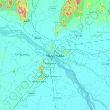
Nome: Mapa topográfico Vijayawada, altitude, relevo.
Altitude média: 36 m
Altitude mínima: 7 m
Altitude máxima: 447 m
Vijayawada lies on the banks of Krishna river, covered by hills and canals. and at an altitude of 11 m (36 ft) above sea level. Three canals originating from the north side of the Prakasam Barrage reservoir — Eluru, Bandar, and Ryves — flow through the city.