
Mapa topográfico Kurnool
Mapa interativo
Clique no mapa para exibir a altitude.
Sobre este mapa
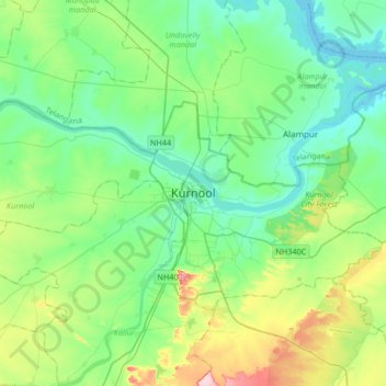
Nome: Mapa topográfico Kurnool, altitude, relevo.
Local: Kurnool, Andhra Pradesh, 518001, India (15.67093 77.88254 15.99093 78.20254)
Altitude média: 307 m
Altitude mínima: 259 m
Altitude máxima: 453 m
Kurnool is located at 15°50′00″N 78°03′00″E / 15.8333°N 78.05°E / 15.8333; 78.05. It has an average elevation of 273 metres (898 feet). Kurnool lies on the banks of the Tungabhadra River. The Hundri and Neeva rivers also flow through the city. The K.C.Canal (Kurnool–Cuddapah) was built by the Dutch for transportation, but later used for irrigation.