
Mapa topográfico Lac Jean Pere
Mapa interativo
Clique no mapa para exibir a altitude.
Sobre este mapa
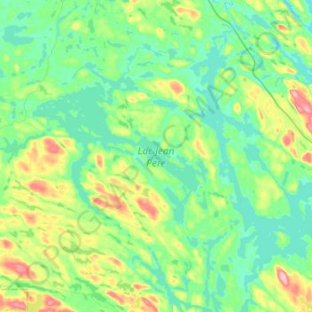
Nome: Mapa topográfico Lac Jean Pere, altitude, relevo.
Altitude média: 386 m
Altitude mínima: 353 m
Altitude máxima: 479 m
Outros mapas topográficos
Clique em um mapa para visualizar sua topografia, sua altitude e seu relevo.
Lac Doolittle
Canada > Québec > La Vallée-de-la-Gatineau > Lac-Pythonga
Lac Doolittle, Lac-Pythonga, La Vallée-de-la-Gatineau, Outaouais, Québec, Canada
Altitude média: 379 m
Lac Rhéaume
Canada > Québec > La Vallée-de-la-Gatineau > Lac-Pythonga
Lac Rhéaume, Lac-Pythonga, La Vallée-de-la-Gatineau, Outaouais, Québec, Canada
Altitude média: 296 m
Lac Camatose
Canada > Québec > La Vallée-de-la-Gatineau > Lac-Pythonga
Lac Camatose, Lac-Pythonga, La Vallée-de-la-Gatineau, Outaouais, Québec, Canada
Altitude média: 365 m
Ruisseau Antostagan
Canada > Québec > La Vallée-de-la-Gatineau > Lac-Pythonga
Ruisseau Antostagan, Lac-Pythonga, La Vallée-de-la-Gatineau, Outaouais, Québec, Canada
Altitude média: 395 m
Lac Camatose
Canada > Québec > La Vallée-de-la-Gatineau > Lac-Pythonga
Lac Camatose, Lac-Pythonga, La Vallée-de-la-Gatineau, Outaouais, Québec, Canada
Altitude média: 362 m