
Mapa topográfico Sunnyhill Park
Mapa interativo
Clique no mapa para exibir a altitude.
Sobre este mapa
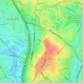
Nome: Mapa topográfico Sunnyhill Park, altitude, relevo.
Altitude média: 62 m
Altitude mínima: 41 m
Altitude máxima: 91 m
Outros mapas topográficos
Clique em um mapa para visualizar sua topografia, sua altitude e seu relevo.
Poulter Park
United Kingdom > England > Greater London > London
Poulter Park, Rosehill, London Borough of Sutton, London, Greater London, England, SM4 6AS, United Kingdom
Altitude média: 31 m
Elephant Park
United Kingdom > England > Greater London > London
Elephant Park, Browning Estate, Elephant and Castle, London, London Borough of Southwark, Greater London, England, SE17, United Kingdom
Altitude média: 7 m