
Mapa topográfico Bad Rodach
Mapa interativo
Clique no mapa para exibir a altitude.
Sobre este mapa
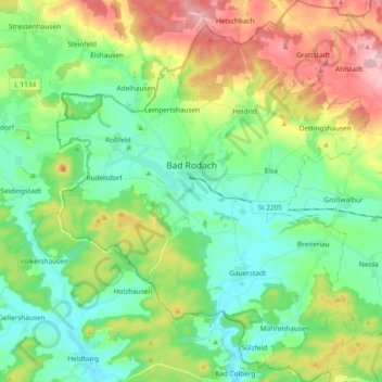
Nome: Mapa topográfico Bad Rodach, altitude, relevo.
Local: Bad Rodach, Landkreis Coburg, Bayern, 96476, Deutschland (50.27308 10.71232 50.39271 10.86477)
Altitude média: 352 m
Altitude mínima: 284 m
Altitude máxima: 492 m
Outros mapas topográficos
Clique em um mapa para visualizar sua topografia, sua altitude e seu relevo.
Heldritt
Deutschland > Bayern > Landkreis Coburg > Bad Rodach
Heldritt, Bad Rodach, Landkreis Coburg, Bayern, 96476, Deutschland
Altitude média: 374 m
Ahlstadt
Deutschland > Bayern > Landkreis Coburg
Ahlstadt, Meeder, Landkreis Coburg, Bayern, Deutschland
Altitude média: 435 m
Sonnefeld
Deutschland > Bayern > Landkreis Coburg
Sonnefeld, Landkreis Coburg, Bayern, 96242, Deutschland
Altitude média: 354 m
Kleingarnstadt
Deutschland > Bayern > Landkreis Coburg
Kleingarnstadt, Ebersdorf b.Coburg, Landkreis Coburg, Bayern, Deutschland
Altitude média: 385 m
Hattersdorf
Deutschland > Bayern > Landkreis Coburg > Seßlach
Hattersdorf, Seßlach, Landkreis Coburg, Bayern, 96145, Deutschland
Altitude média: 300 m
Ahorn
Deutschland > Bayern > Landkreis Coburg
Ahorn, Landkreis Coburg, Bayern, 96482, Deutschland
Altitude média: 333 m
Rödental
Deutschland > Bayern > Landkreis Coburg
Rödental, Landkreis Coburg, Bayern, 96472, Deutschland
Altitude média: 381 m
Neustadt bei Coburg
Deutschland > Bayern > Landkreis Coburg
Neustadt bei Coburg, Landkreis Coburg, Bayern, 96465, Deutschland
Altitude média: 372 m
Ebersdorf b.Coburg
Deutschland > Bayern > Landkreis Coburg
Ebersdorf b.Coburg, Landkreis Coburg, Bayern, 96237, Deutschland
Altitude média: 351 m
Hassenberg
Deutschland > Bayern > Landkreis Coburg > Hassenberg
Hassenberg, Sonnefeld, Landkreis Coburg, Bayern, 96268, Deutschland
Altitude média: 338 m
Scherneck
Deutschland > Bayern > Landkreis Coburg
Scherneck, Untersiemau, Landkreis Coburg, Bayern, 96253, Deutschland
Altitude média: 307 m
Grub am Forst
Deutschland > Bayern > Landkreis Coburg > Grub a.Forst > Grub am Forst
Grub am Forst, Grub a.Forst, Grub am Forst (VGem), Landkreis Coburg, Bayern, 96271, Deutschland
Altitude média: 343 m
Itzgrund
Deutschland > Bayern > Landkreis Coburg
Itzgrund, Landkreis Coburg, Bayern, 96274, Deutschland
Altitude média: 307 m
Seßlach
Deutschland > Bayern > Landkreis Coburg
Seßlach, Landkreis Coburg, Bayern, 96145, Deutschland
Altitude média: 325 m
Lahm
Deutschland > Bayern > Landkreis Coburg > Ebersdorf b.Coburg
Lahm, Ebersdorf b.Coburg, Landkreis Coburg, Bayern, 96271, Deutschland
Altitude média: 361 m
Weitramsdorf
Deutschland > Bayern > Landkreis Coburg
Weitramsdorf, Landkreis Coburg, Bayern, 96479, Deutschland
Altitude média: 341 m
Boderndorf
Deutschland > Bayern > Landkreis Coburg > Neustadt bei Coburg
Boderndorf, Neustadt bei Coburg, Landkreis Coburg, Bayern, 96465, Deutschland
Altitude média: 369 m
Untersiemau
Deutschland > Bayern > Landkreis Coburg
Untersiemau, Landkreis Coburg, Bayern, 96253, Deutschland
Altitude média: 319 m
Meeder
Deutschland > Bayern > Landkreis Coburg
Meeder, Landkreis Coburg, Bayern, 96484, Deutschland
Altitude média: 398 m