
Mapa topográfico Hull
Mapa interativo
Clique no mapa para exibir a altitude.
Sobre este mapa
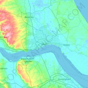
Nome: Mapa topográfico Hull, altitude, relevo.
Local: Hull, Kingston upon Hull, England, HU1 3RJ, United Kingdom (53.58357 -0.49948 53.90357 -0.17948)
Altitude média: 21 m
Altitude mínima: -4 m
Altitude máxima: 168 m
Kingston upon Hull is on the northern bank of the Humber Estuary. The city centre is west of the River Hull and close to the Humber. The city is built upon alluvial and glacial deposits which overlie chalk rocks but the underlying chalk has no influence on the topography. The land within the city is generally very flat and is only 2 to 4 metres (6.5 to 13 ft) above sea level. Because of the relative flatness of the site there are few physical constraints upon building and many open areas are the subject of pressures to build.
Outros mapas topográficos
Clique em um mapa para visualizar sua topografia, sua altitude e seu relevo.
Sutton
United Kingdom > England > Kingston upon Hull > Sutton
Sutton, Kingston upon Hull, Yorkshire and the Humber, England, HU7 4UF, United Kingdom
Altitude média: 3 m