
Mapa topográfico Salt Lake City
Mapa interativo
Clique no mapa para exibir a altitude.
Salt Lake City
De acordo com o United States Census Bureau, a cidade tem uma área total de 287 km², dos quais 285,8 km² estão cobertos por terra e 1,2 km² por água. Salt Lake tem uma altitude média de 1 288 m. O ponto mais baixo dentro dos limites da cidade é de 1 280 m, próximo do rio Jordan e do Great Salt Lake, e a altitude mais elevada é Grandview Peak, a 2 868 m.
Sobre este mapa
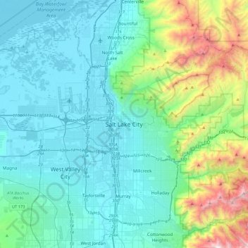
Nome: Mapa topográfico Salt Lake City, altitude, relevo.
Altitude média: 1625 m
Altitude mínima: 1278 m
Altitude máxima: 3231 m