
Faça uma doação
Prepare-se para a sua próxima aventura:
Como Associado da Amazon, este site recebe uma comissão sobre compras elegíveis sem custo adicional para si.
Mapa topográfico Puebla
Clique no mapa para exibir a altitude.
Faça uma doação
Prepare-se para a sua próxima aventura:
Como Associado da Amazon, este site recebe uma comissão sobre compras elegíveis sem custo adicional para si.
Puebla
Ao norte da cidade, localiza-se perto do vulcão inativo Malintzín, a uma altitude de 2 125 metros, próximo aos vulcões Popocatépetl e Iztaccihuatl, no eixo transversal vulcânico.
Faça uma doação
Prepare-se para a sua próxima aventura:
Como Associado da Amazon, este site recebe uma comissão sobre compras elegíveis sem custo adicional para si.
Sobre este mapa
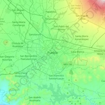
Nome: Mapa topográfico Puebla, altitude, relevo.
Local: Puebla, Municipio de Puebla, Puebla, 72000, México (18.88372 -98.35815 19.20372 -98.03815)
Altitude média: 2233 m
Altitude mínima: 1829 m
Altitude máxima: 3633 m
Faça uma doação
Prepare-se para a sua próxima aventura:
Como Associado da Amazon, este site recebe uma comissão sobre compras elegíveis sem custo adicional para si.