
Obrigado por apoiar este site ❤️
Faça uma doação
Faça uma doação
Prepare-se para a sua próxima aventura:
Como Associado da Amazon, este site recebe uma comissão sobre compras elegíveis sem custo adicional para si.
Mapa topográfico La Paz
Clique no mapa para exibir a altitude.
Obrigado por apoiar este site ❤️
Faça uma doação
Faça uma doação
Prepare-se para a sua próxima aventura:
Como Associado da Amazon, este site recebe uma comissão sobre compras elegíveis sem custo adicional para si.
Sobre este mapa
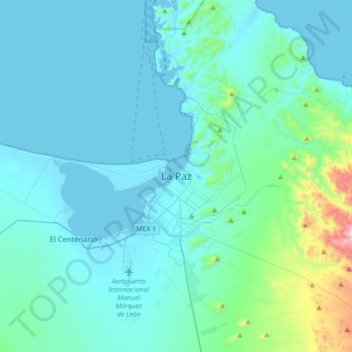
Nome: Mapa topográfico La Paz, altitude, relevo.
Altitude média: 114 m
Altitude mínima: -2 m
Altitude máxima: 1100 m
Obrigado por apoiar este site ❤️
Faça uma doação
Faça uma doação
Prepare-se para a sua próxima aventura:
🩹Kits de Primeiros Socorros Portáteis - Essenciais de emergência compactos para entusiastas de outdoor
Como Associado da Amazon, este site recebe uma comissão sobre compras elegíveis sem custo adicional para si.