
Faça uma doação
Prepare-se para a sua próxima aventura:
Como Associado da Amazon, este site recebe uma comissão sobre compras elegíveis sem custo adicional para si.
Mapa topográfico Monterrei
Clique no mapa para exibir a altitude.
Faça uma doação
Prepare-se para a sua próxima aventura:
Como Associado da Amazon, este site recebe uma comissão sobre compras elegíveis sem custo adicional para si.
Monterrei
Monterrey possui um clima semiárido. O clima é extremo: muito quente no verão e frio no inverno. A precipitação média anual gira em torno de 580 mm. As chuvas se distribuem principalmente de junho a outubro. A temperatura média anual é de 21 °C, porém, esta média oculta a enorme oscilação térmica das estações. No verão, são comuns as temperaturas superiores a 30 °C. Em julho e agosto, a temperatura máxima média é de 35 °C, ultrapassando os 35 °C por muitos dias seguidos desde junho até os primeiros dias de setembro. No inverno, constantemente chegam a região massas de ar frio acompanhadas muitas vezes por umidade da costa, o que faz a temperatura cair notavelmente, sendo registrado, todos os anos, ao menos dois ou três dias com temperaturas de 0 °C ou menos. Também no inverno são frequentes as mudanças climáticas, podendo a temperatura subir anormalmente até os 25 °C. Devido a escassa altitude da cidade, as nevadas não são muito frequentes; a última grande nevada que acumulou vários centímetros no solo ocorreu em 24 de dezembro de 2004, uma ligeira nevada se registrou em 17 de janeiro de 2007, embora a maior parte dela tenha sido granizo e gelo. Neva em média a cada 4 a 7 anos na cidade, entretanto, na região da Sierra Madre Oriental, se registram geadas e nevadas frequentes. Em geral, as temperaturas no ano vão desde 0 °C ou ligeiramente menos nos dias de inverno até os 38 °C ou 39 °C em julho e agosto.
Faça uma doação
Prepare-se para a sua próxima aventura:
Como Associado da Amazon, este site recebe uma comissão sobre compras elegíveis sem custo adicional para si.
Sobre este mapa
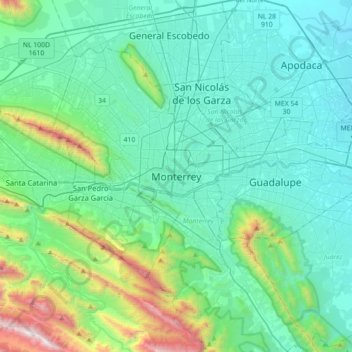
Nome: Mapa topográfico Monterrei, altitude, relevo.
Local: Monterrei, Monterrey, Nuevo León, 64010, México (25.52020 -100.47526 25.84020 -100.15526)
Altitude média: 753 m
Altitude mínima: 381 m
Altitude máxima: 2521 m
Faça uma doação
Prepare-se para a sua próxima aventura:
Como Associado da Amazon, este site recebe uma comissão sobre compras elegíveis sem custo adicional para si.