Geolocalizar

Mapa topográfico Snowdon

Mapa interativo

Clique no mapa para exibir a altitude.

Sobre este mapa

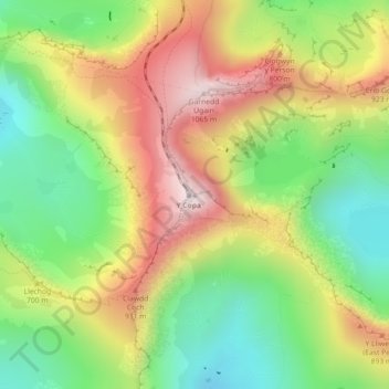
Nome: Mapa topográfico Snowdon, altitude, relevo.

Local: Snowdon, Llanberis Path, Betws Garmon, Gwynedd, Wales, LL55 4UL, United Kingdom (53.06844 -4.07628 53.06854 -4.07618)

Altitude média: 692 m

Altitude mínima: 390 m

Altitude máxima: 1061 m

Snowdon (/ˈsnoʊdən/) or Yr Wyddfa (pronounced [ər ˈʊɨ̞̯ðva] (listen)), is the highest mountain in Wales, at an elevation of 1,085 metres (3,560 ft) above sea level, and the highest point in the British Isles outside the Scottish Highlands. It is located in Snowdonia National Park (Parc Cenedlaethol Eryri) in Gwynedd (historic county of Caernarfonshire).

Wikipedia (CC-BY-SA 3.0)