
Mapa topográfico Pedra Azul
Mapa interativo
Clique no mapa para exibir a altitude.
Pedra Azul
Em 1 de junho de 1912, houve a elevação do distrito de Fortaleza a município, e em 1943 o nome da cidade foi mudado para Pedra Azul. O novo nome foi sugerido pelo pedrazulense e imortal da Academia Mineira de Letras Nelson de Faria.
Sobre este mapa
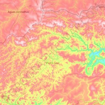
Nome: Mapa topográfico Pedra Azul, altitude, relevo.
Altitude média: 773 m
Altitude mínima: 418 m
Altitude máxima: 1068 m
Outros mapas topográficos
Clique em um mapa para visualizar sua topografia, sua altitude e seu relevo.
Serra da Mantiqueira
Brasil > Minas Gerais > Região Metropolitana do Vale do Paraíba e Litoral Norte > Passa Quatro
A serra tem uma formação geológica datada da era arqueana que compreende um maciço rochoso que possui grande área de terras altas, entre mil e quase três mil metros de altitude, ao longo das divisas dos estados de Minas Gerais, São Paulo e Rio de Janeiro. Na serra da Mantiqueira existem diversas…
Altitude média: 2271 m
Serra do Lenheiro
Brasil > Minas Gerais > São João del-Rei > São Gonçalo do Amarante
Altitude média: 1053 m
São José dos Cocais
Brasil > Minas Gerais > Região Metropolitana do Vale do Aço > Coronel Fabriciano
Altitude média: 826 m
Montes Claros
Brasil > Minas Gerais > Montes Claros
O ponto central da cidade tem uma altitude média de 655,21 metros. O ponto culminante do município é o Morro Vermelho, onde a altitude chega aos 1 075 metros. Em Montes Claros predomina um relevo ondulado, com mares de morros e montanhas. A altitude mínima, que é de 502 metros, encontra-se na foz do…
Altitude média: 776 m
Lagoa dos Ingleses
Brasil > Minas Gerais > Região Metropolitana de Belo Horizonte > Nova Lima
Altitude média: 1335 m
Lagoa Olhos d'Água
Brasil > Minas Gerais > Região Metropolitana de Belo Horizonte > Lagoa Santa
Altitude média: 772 m
Praça Nova York
Brasil > Minas Gerais > Região Metropolitana de Belo Horizonte > Belo Horizonte
Altitude média: 1007 m
Ribeirão do Onça
Brasil > Minas Gerais > Região Metropolitana de Belo Horizonte > Belo Horizonte
Altitude média: 751 m
Ribeirão Santa Rita
Brasil > Minas Gerais > Região Integrada de Desenvolvimento do Distrito Federal e Entorno > Unaí
Altitude média: 601 m
Pico do Cristal
Brasil > Minas Gerais > Alto Caparaó
O pico do Cristal é o sexto mais alto pico brasileiro, com 2.769,05 metros de altitude, segundo a medição feita pelo IBGE e pelo Instituto Militar de Engenharia, através do Projeto Pontos Culminantes do Brasil, e revista pelo IBGE através de novo mapeamento do geoide do território brasileiro em 2016.
Altitude média: 2419 m
Pista de caminhada do Alphaville Lagoa dos Ingleses
Brasil > Minas Gerais > Região Metropolitana de Belo Horizonte > Nova Lima
Altitude média: 1338 m
Lagoa do Nado
Brasil > Minas Gerais > Região Metropolitana de Belo Horizonte > Belo Horizonte
Altitude média: 793 m
Parque Mata das Borboletas
Brasil > Minas Gerais > Região Metropolitana de Belo Horizonte > Belo Horizonte
Altitude média: 1036 m
Itacolomi
Brasil > Minas Gerais > Mariana
O pico do Itacolomi é uma formação rochosa com 1 772 m de altitude localizada no limite dos municípios de Mariana e Ouro Preto, em Minas Gerais. Está inserido no Parque Estadual do Itacolomi.
Altitude média: 1463 m
Belo Horizonte
Brasil > Minas Gerais > Região Metropolitana de Belo Horizonte
Apoiado na pequena lavoura, na criação e comercialização de gado e na fabricação de farinha, o arraial progrediu. A topografia da região favoreceu o estabelecimento de uma povoação dada à agricultura e à vida pastoril. Os habitantes deram o nome de Curral del Rei, por causa do cercado ou curral ali…
Altitude média: 904 m
Parque Estadual do Pico do Itambé
Brasil > Minas Gerais > Santo Antônio do Itambé
Em 21 de janeiro de 1998 foi criado o Parque Estadual do Pico do Itambé, envolvendo os municípios de Serro (930 ha), Santo Antônio do Itambé (2.926 ha) e Serra Azul (840 ha), concretizando-se um dos sonhos das comunidades vizinhas. Constituído por aprox. 4.700 hectares, o parque tem a cobertura vegetal…
Altitude média: 1108 m
Santana do Rio Preto - Cabeça de Boi
Brasil > Minas Gerais > Itambé do Mato Dentro
Altitude média: 797 m
Serra do Rola Moça
Brasil > Minas Gerais > Região Metropolitana de Belo Horizonte > Ibirité
Altitude média: 1226 m
São Francisco de Assis
Brasil > Minas Gerais > Região Metropolitana de Belo Horizonte > Lagoa Santa
Altitude média: 754 m
Catatau
Brasil > Minas Gerais > Região Metropolitana de Belo Horizonte > Florestal
Altitude média: 792 m
Piumhi
Brasil > Minas Gerais > Piumhi
Piumhi está localizada na Mesorregião Oeste do Estado de Minas Gerais (região centro-oeste), com 902 km² de área e uma altitude de 793 metros, clima tropical com a temperatura média de 22 graus Celsius e vegetação de cerrado.
Altitude média: 806 m