
Faça uma doação
Prepare-se para a sua próxima aventura:
Como Associado da Amazon, este site recebe uma comissão sobre compras elegíveis sem custo adicional para si.
Mapa topográfico Mürren
Clique no mapa para exibir a altitude.
Faça uma doação
Prepare-se para a sua próxima aventura:
Como Associado da Amazon, este site recebe uma comissão sobre compras elegíveis sem custo adicional para si.
Sobre este mapa
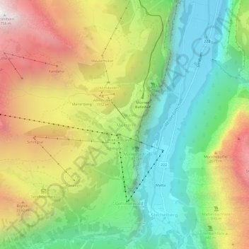
Nome: Mapa topográfico Mürren, altitude, relevo.
Altitude média: 1597 m
Altitude mínima: 799 m
Altitude máxima: 2735 m
Faça uma doação
Prepare-se para a sua próxima aventura:
Como Associado da Amazon, este site recebe uma comissão sobre compras elegíveis sem custo adicional para si.
Outros mapas topográficos
Clique em um mapa para visualizar sua topografia, sua altitude e seu relevo.
Lauterbrunnen
Switzerland > Bern > Interlaken-Oberhasli administrative district
Altitude média: 2316 m
Faça uma doação
Prepare-se para a sua próxima aventura:
Como Associado da Amazon, este site recebe uma comissão sobre compras elegíveis sem custo adicional para si.
Meiringen
Switzerland > Bern > Interlaken-Oberhasli administrative district
On the right bank of the Aare, the municipality of Meiringen rises from an elevation of 600 m (2,000 ft) on the valley floor to the Brünig Pass at 1,008 m (3,307 ft) and beyond that to a point at 1,375 m (4,511 ft) on the slopes of the Wilerhorn. On the left bank it stretches up into the Alps and reaches an…
Altitude média: 1430 m
Lauterbrunnen
Switzerland > Bern > Interlaken-Oberhasli administrative district
Altitude média: 2316 m
Faça uma doação
Prepare-se para a sua próxima aventura:
Como Associado da Amazon, este site recebe uma comissão sobre compras elegíveis sem custo adicional para si.
Innertkirchen
Switzerland > Bern > Interlaken-Oberhasli administrative district
The large alpine municipality is located at the confluence of the Urbach and Gadmer streams into the Aare river. It includes the Urbach valley, the Gadmen valley, the Gen valley, the Wetterhorn mountain and the Gauli Glacier. Innertkirchen was created out of the Bäuerten (farming communities) of Grund,…
Altitude média: 1963 m
Matten bei Interlaken
Switzerland > Bern > Interlaken-Oberhasli administrative district
Altitude média: 781 m
Faça uma doação
Prepare-se para a sua próxima aventura:
Como Associado da Amazon, este site recebe uma comissão sobre compras elegíveis sem custo adicional para si.
Triftsee
Switzerland > Bern > Interlaken-Oberhasli administrative district > Innertkirchen
Altitude média: 2025 m
Faça uma doação
Prepare-se para a sua próxima aventura:
Como Associado da Amazon, este site recebe uma comissão sobre compras elegíveis sem custo adicional para si.
Wilderswil
Switzerland > Bern > Interlaken-Oberhasli administrative district
The municipality extends for some 8 km (5.0 mi) from the village, along the west bank of the Lütschine river, and includes the flanks of the mountains that border that valley to the west. Its altitude ranges from some 580 m (1,900 ft), on the Bödeli plain, to 2,413 m (7,917 ft), at the summit of Sulegg. It…
Altitude média: 1198 m
Meiringen
Switzerland > Bern > Interlaken-Oberhasli administrative district
On the right bank of the Aare, the municipality of Meiringen rises from an elevation of 600 m (2,000 ft) on the valley floor to the Brünig Pass at 1,008 m (3,307 ft) and beyond that to a point at 1,375 m (4,511 ft) on the slopes of the Wilerhorn. On the left bank it stretches up into the Alps and reaches an…
Altitude média: 1430 m
Faça uma doação
Prepare-se para a sua próxima aventura:
Como Associado da Amazon, este site recebe uma comissão sobre compras elegíveis sem custo adicional para si.
Iseltwald
Switzerland > Bern > Interlaken-Oberhasli administrative district
The municipality's area also includes a large area of mountainside along the south shore of the lake, of which the lower areas are heavily wooded. These slopes extend up to the summit of the Faulhorn mountain, at an altitude of 2,680 m (8,790 ft).
Altitude média: 1218 m
Faça uma doação
Prepare-se para a sua próxima aventura:
Como Associado da Amazon, este site recebe uma comissão sobre compras elegíveis sem custo adicional para si.
Innertkirchen
Switzerland > Bern > Interlaken-Oberhasli administrative district > Innertkirchen
The large alpine municipality is located at the confluence of the Urbach and Gadmer streams into the Aare river. It includes the Urbach valley, the Gadmen valley, the Gen valley, the Wetterhorn mountain and the Gauli Glacier. Innertkirchen was created out of the Bäuerten (farming communities) of Grund,…
Altitude média: 1945 m
Guttannen
Switzerland > Bern > Interlaken-Oberhasli administrative district
By Swiss standards, the municipality is large in area; by comparison it is larger than the entire Canton of Appenzell Innerrhoden. In elevation it stretches from the valley floor which is between 800–1,300 m (2,600–4,300 ft) into the high alpine peaks of the Finsteraarhorn group.
Altitude média: 2334 m
Faça uma doação
Prepare-se para a sua próxima aventura:
Como Associado da Amazon, este site recebe uma comissão sobre compras elegíveis sem custo adicional para si.
Lauterbrunnen
Switzerland > Bern > Interlaken-Oberhasli administrative district
Altitude média: 2316 m
Matten bei Interlaken
Switzerland > Bern > Interlaken-Oberhasli administrative district
Altitude média: 781 m
Faça uma doação
Prepare-se para a sua próxima aventura:
Como Associado da Amazon, este site recebe uma comissão sobre compras elegíveis sem custo adicional para si.
Gündlischwand
Switzerland > Bern > Interlaken-Oberhasli administrative district
Altitude média: 1268 m
Lauterbrunnen
Switzerland > Bern > Interlaken-Oberhasli administrative district
Altitude média: 2316 m
Lauterbrunnen
Switzerland > Bern > Interlaken-Oberhasli administrative district
Altitude média: 2316 m
Aareschlucht
Switzerland > Bern > Interlaken-Oberhasli administrative district > Meiringen
Altitude média: 819 m
Faça uma doação
Prepare-se para a sua próxima aventura:
Como Associado da Amazon, este site recebe uma comissão sobre compras elegíveis sem custo adicional para si.
Gsteigwiler
Switzerland > Bern > Interlaken-Oberhasli administrative district > Gsteigwiler
Altitude média: 984 m
Unteraargletscher
Switzerland > Bern > Interlaken-Oberhasli administrative district > Guttannen
Altitude média: 2631 m