Mapa topográfico Blatten
Mapa interativo
Clique no mapa para exibir a altitude.
Sobre este mapa
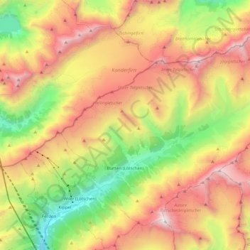
Nome: Mapa topográfico Blatten, altitude, relevo.
Local: Blatten, Westlich Raron, Wallis, 3919, Switzerland (46.38912 7.76850 46.49825 7.96555)
Altitude média: 2536 m
Altitude mínima: 1267 m
Altitude máxima: 3905 m
Blatten lies in the Lötschental valley south of the Bernese Alps. The municipality is located in the Westlich Raron district, and is the highest inhabited part of the Lötschental valley at an elevation of 1,540 m (5,050 ft). It consists of the village of Blatten and the hamlets of Eisten, Ried and Weissenried. At the head of the road up the valley, Fafleralp is the site of a well known hotel.
Outros mapas topográficos
Clique em um mapa para visualizar sua topografia, sua altitude e seu relevo.
Grosshorn
Switzerland > Wallis > Westlich Raron > Blatten
Grosshorn, Blatten, Westlich Raron, Wallis, 3919, Switzerland
Altitude média: 3073 m
Lauchernalp
Switzerland > Wallis > Westlich Raron
Lauchernalp, Wiler (Lötschen), Westlich Raron, Wallis, 3918, Switzerland
Altitude média: 1956 m
Raron
Switzerland > Wallis > Westlich Raron
Raron, Westlich Raron, Wallis, 3942, Switzerland
Altitude média: 1712 m
Breithorn
Switzerland > Wallis > Westlich Raron > Blatten
Breithorn, Blatten, Westlich Raron, Wallis, 3919, Switzerland
Altitude média: 2914 m