
Faça uma doação
Prepare-se para a sua próxima aventura:
Como Associado da Amazon, este site recebe uma comissão sobre compras elegíveis sem custo adicional para si.
Mapa topográfico Grand Teton National Park
Clique no mapa para exibir a altitude.
Faça uma doação
Prepare-se para a sua próxima aventura:
Como Associado da Amazon, este site recebe uma comissão sobre compras elegíveis sem custo adicional para si.
Grand Teton National Park
O Parque Nacional de Grand Teton (Grand Teton National Park em inglês) é um parque nacional dos Estados Unidos, situado no oeste do estado de Wyoming, a sul do Parque Nacional de Yellowstone. A sua designação tem origem no nome do pico mais alto das Montanhas Teton, o Grand Teton, com 4 197 m de altitude.
Faça uma doação
Prepare-se para a sua próxima aventura:
Como Associado da Amazon, este site recebe uma comissão sobre compras elegíveis sem custo adicional para si.
Sobre este mapa
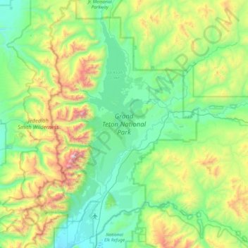
Nome: Mapa topográfico Grand Teton National Park, altitude, relevo.
Altitude média: 2409 m
Altitude mínima: 1893 m
Altitude máxima: 4117 m
Faça uma doação
Prepare-se para a sua próxima aventura:
Como Associado da Amazon, este site recebe uma comissão sobre compras elegíveis sem custo adicional para si.
Outros mapas topográficos
Clique em um mapa para visualizar sua topografia, sua altitude e seu relevo.
Grand Teton
Estados Unidos da América > Wyoming > Teton County
Grand Teton é uma montanha situada no Parque Nacional de Grand Teton, no noroeste do Wyoming (Estados Unidos). Com 4199 m de altitude no top do seu pico piramidal, é o ponto culminante do parque nacional e da cordilheira Teton, e a segunda montanha mais alta do Wyoming. Tem quase 2000 m de proeminência…
Altitude média: 3330 m